This website has been designed for the purpose of understanding and exploring the Cuyahoga watershed in Northeastern Ohio, specifically the lower reach near the river's confluence with Lake Erie. It is a project designed for Integrated Watershed Management FW326, a Natural Resources class at OSU Cascades in Bend, Oregon.
The Cuyahoga River watershed and the river itself are famous for many things: it is the river that has been on fire many times due to oil pollution; it flows through a major metropolitan city, Cleveland, and empties into Lake Erie; and it was once known as one of the richest natural resource areas in the United States. However, much of this has changed, for better and worse.
The Cuyahoga River watershed and the river itself are famous for many things: it is the river that has been on fire many times due to oil pollution; it flows through a major metropolitan city, Cleveland, and empties into Lake Erie; and it was once known as one of the richest natural resource areas in the United States. However, much of this has changed, for better and worse.
|

|
|
Part 1:
The Physical Characteristics of the Watershed
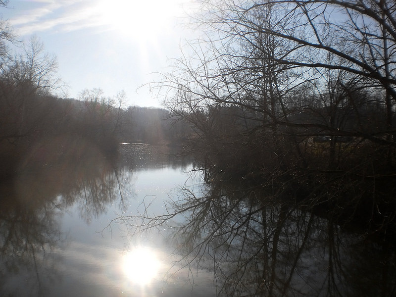
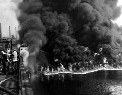
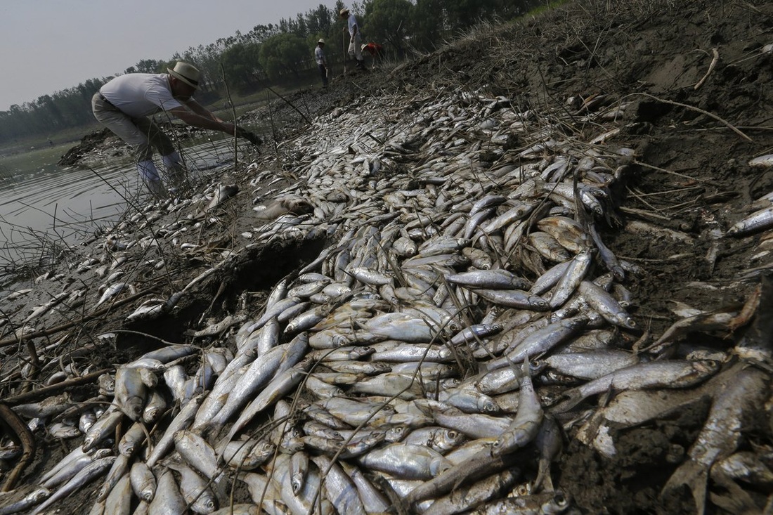
The Cuyahoga watershed can be both beautiful and ugly, as shown above. The river begins at an elevation of 1,093 feet and empties into Lake Erie at an elevation of 571 feet, with an overall length of 84.9 miles The watershed drains an area of 813 square miles. Like most rivers, the relief can be defined as steep at the start of the river and flattening as it nears its end (USGS 2015).
The Physical Characteristics of the Watershed
The Cuyahoga watershed can be both beautiful and ugly, as shown above. The river begins at an elevation of 1,093 feet and empties into Lake Erie at an elevation of 571 feet, with an overall length of 84.9 miles The watershed drains an area of 813 square miles. Like most rivers, the relief can be defined as steep at the start of the river and flattening as it nears its end (USGS 2015).

|
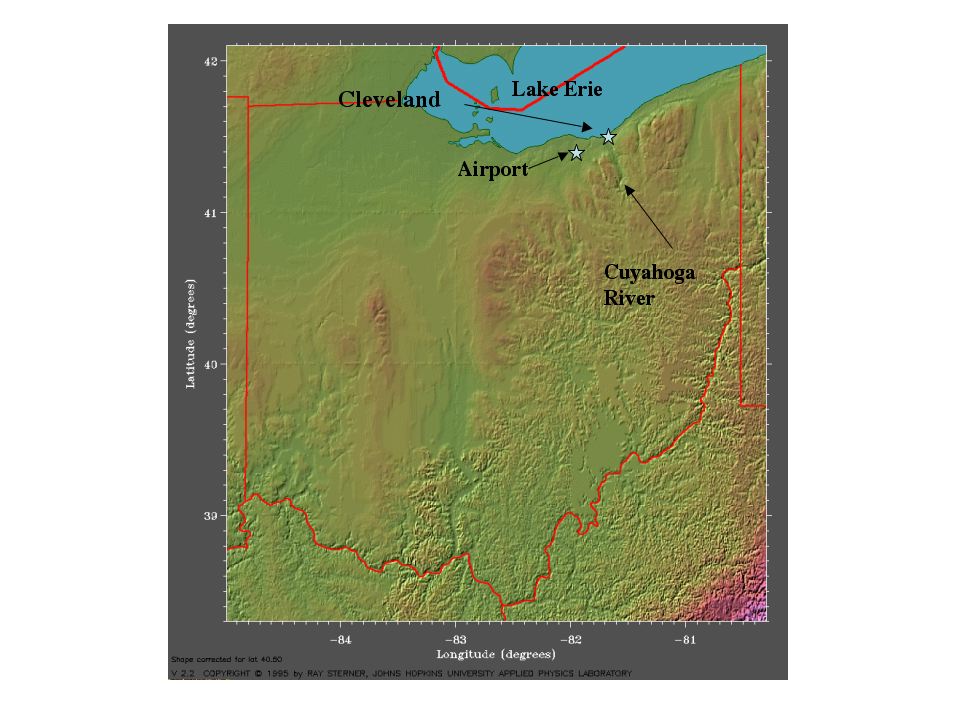
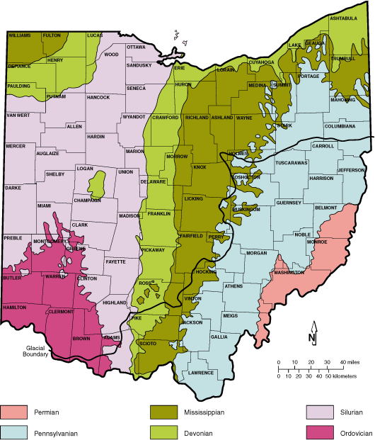
A map of the entire Cuyahoga watershed including its numerous tributaries (USGS). Below is a topographic map of Ohio.
|
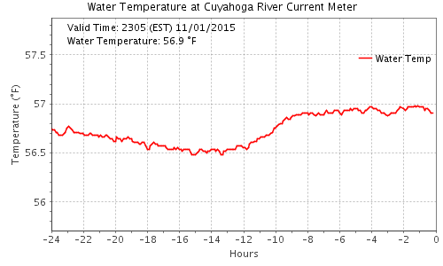
Average water temperatures at the mouth of the of the Cuyahoga river (USGS).
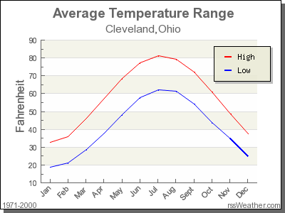
(rssweather.com).
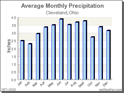
(rssweather.com)
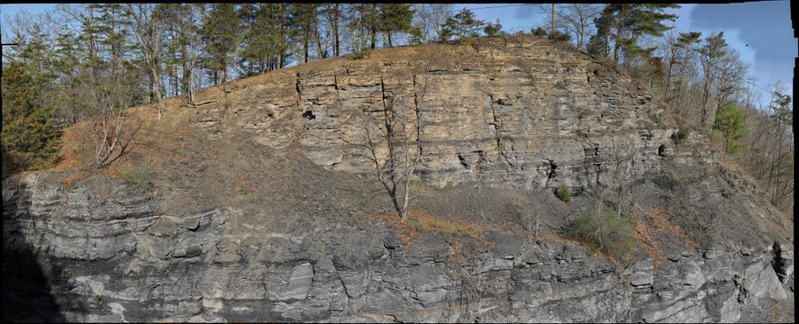
Typical outcrop of Devonian shale. These layers dominate the geology in most of the Cuyahoga River watershed. Brittle layers of fine rock were deposited roughly 300 million years ago, through the erosion of the Appalachian Mountains and the deposition of dead algae. There has been interest in oil and gas exploration in the broader region, such as New York and Pennsylvania. However, the Northeastern corner of Ohio has largely been spared. The soils created by the easily eroded shales are of a very fine nature and in the lower stretches of the river create a very sediment-laden system. In the floodplain areas, these soils are known for being quality arable land. There is a large amount of runoff from the shale-derived soils due to their small pore space, leading to extreme flood events (Geologic Society of America).
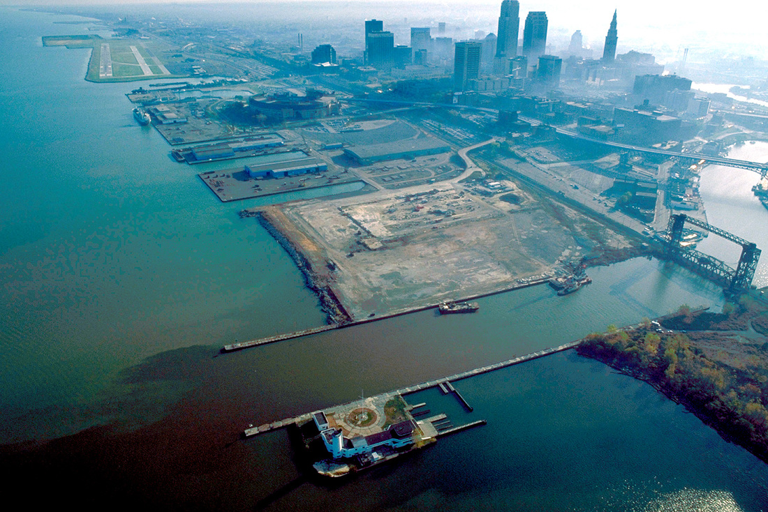
Throughout the lower stretches of the river system, the Cuyahoga is mostly a meandering, flat river with its flow being maintained through a series of dams and canals.
Throughout the lower stretches of the river system, the Cuyahoga is mostly a meandering, flat river with its flow being maintained through a series of dams and canals.
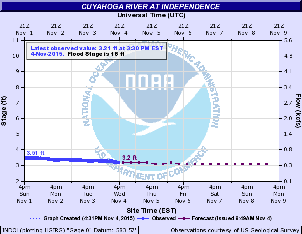
A weekly hydrograph . Unfortunately, a yearly hydrograph could not be obtained (USGS).
|
|
|
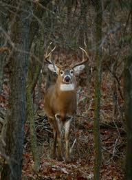
Once named "Forest City", Cleveland was a beautiful forested area teaming with wildlife, and full of vibrant rivers and lakes. The watershed was, and still is, home to many Northeastern woodland animal species including deer, beavers, raccoons, grey squirrels, black squirrels, and bears. Bird and fish species rely on the waters of the Cuyahoga, as well as Lake Erie. Populations have decreased within the lower stretches of the watershed nearer to Cleveland, secondary to urbanization. During the exploitation era of the 18th and 19th centuries, the Cuyahoga River turned into a major portal for the export of natural resources. The vast forests were cut, rivers were straightened, and canals were built. This was all done in the name of commerce; huge fortunes were made and the natural world suffered.
Today, some things have changed. There is an emphasis on restoring this watershed; however, with a large human population and an increasing demand for resources, things are not going well.
Today, some things have changed. There is an emphasis on restoring this watershed; however, with a large human population and an increasing demand for resources, things are not going well.

|
Part 2:
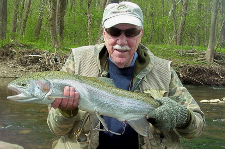
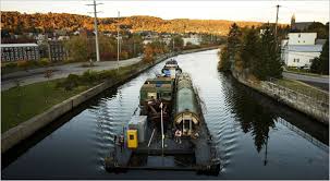
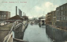
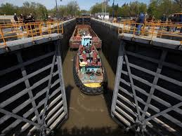
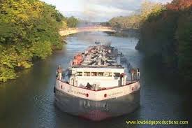
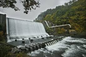
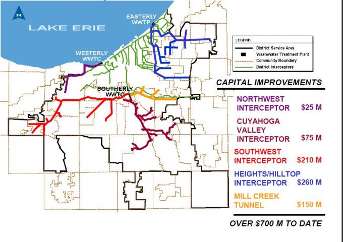
The Social and Economic Uses of the Watershed The Cuyahoga was once a valuable spawning area for many of the fish coming up from Lake Erie such as trout, muskies, and steelhead. To protect these populations within the lower stretches of the river, the current recommendations are to limit numbers caught for consumption. This is mainly due to the high density of the population in and around the lower Cuyahoga river. The city of Cleveland has a population of 389,521 people, while the entire county of Cuyahoga has a total population of 1,259,828 , making it the most populous county in the state of Ohio. Cleveland covers 77 square miles, while Cuyahoga county covers 1,246 square miles. The population for the most part is urban, with a population density of 1,011 people per square mile (U.S. Census Bureau 2010). Within Cuyahoga county 33% of the land is considered impervious, meaning it is either paved or has a building on it; 6.4% is considered barren, plowed field, beach or hard-packed grassy area; 1.2% is covered with water; 33.1% is forested; 25.6% is living grass (StatsByCity.xls). There are a total of eleven dams along the entire river, an average of one dam every 7.75 miles. However, most of the dams are located in the upper stretches of the river, built primarily for water diversion and flood reduction. The largest dam on the river, the Metro-Parks Gorge Dam, is slated for removal. This dam is in the middle reach of the river, and was built in 1912 for hydro-electricity. In the lower section of the river there are numerous break-walls or cement levees within the city of Cleveland, making the river look more like a canal than a river (ODNR 2013). Canals are a major part of the industrial trade that occurs in Ohio. Many commodities including iron ore, limestone, lumber, coal, oil, and agricultural goods pass through the canal system that connects the upper reaches of the watershed to the Port of Cleveland on Lake Erie. As well, the port is responsible for over $1 billion in trade annually. The Port of Cleveland is the third largest port in the Great Lakes system (portofcleveland.com). The water supply for the city of Cleveland, as well as most of the surrounding areas, comes from Lake Erie. The water is drawn from a pipe that extends 3 miles into the lake. The water that flows through the Cuyahoga watershed is used primarily for transportation of goods, irrigation, and the discharge of sewage (www.clevelandwater.com/your-water/lake-erie0). One exciting development that is occurring within the lower reaches of the watershed is being carried out by the Northeast Ohio Regional Sewer District. This $3 billion project intends to capture and clean untreated sewage throughout the tributaries surrounding the city of Cleveland (theplaindealercleveland.com). This project will be detailed in Part 3. |

Part 3:
Human Impacts and Current Management in the Watershed
It is a well known fact for many of the citizens of Ohio that the industrialized section of the Cuyahoga watershed, roughly the last 50 miles of the river, has been degraded. The river didn't catch fire just once, but more than a dozen times. Industrial effluent, logs, oil from ships, and refineries, all caused the river to be a ticking time bomb just waiting for a spark (Ohio EPA, 2003). The event that caused the great fire of 1969 was caused by a passing train. The train tracks were uneven and literally spread sparks into the river, igniting a fire that could not be extinguished for days. Time Magazine popularized the incident and dubbed Cleveland the "Mistake by the Lake". Unfortunately, the Cuyahoga was not the only river to have caught fire. Many rivers and harbors near industrial areas have burned in the U.S. and around the world. What is most interesting about the Cleveland fires is that they, and the media coverage they were afforded, sparked a change in the laws concerning water quality in the U.S. (National Park Service). The Clean Water Act, which passed in 1972, made it necessary for navigable rivers to meet certain standards of water quality.
Environmental issues that have been listed by the 303d survey for the Cuyahoga River include: organic enrichment, high levels of nutrients such as phosphorus and nitrogen, high bacterial content from sewer overflow, warm temperatures, and an overall change in the flow regime of the river (Ohio EPA, 2003). The problem of the combined sewer overflows occurs when there is a high precipitation event that overwhelms the sewage treatment facilities within the watershed. These events generally take place in the areas with the highest populations, and are due to the combination of street runoff and raw sewage. Once the sewage treatment plants have reached capacity and cannot take anymore flow, the water is directed into the river and into Lake Erie. There is an ongoing project, started in 2007 by the Northeast Ohio Regional Sewer District, that will attempt to fix the problem. It is a 25 year project that will keep 4.5 billion gallons of raw sewage from entering the lake on an annual basis. The bulk of the plan is to capture the sewage in large storage facilities and at the same time increase the size of the underground tunnels that transport the sewage. The plan had an initial budget of $3 billion (McCarty, James F. 2015).
Water rights along the river are based on who owns the land adjacent to the riverbank. The main owners of property in the lower portion of the watershed are municipalities and industries. Most of the water being taken out of the river is used for sewage treatment and industrial uses.
The Ohio Department of Natural Resources monitors all aspects of the river: dissolved oxygen levels, temperature, toxicity levels, and overall system health. The City of Cleveland has also become an active member in restoring the health of the river.
One of the main requirements of the Clean Water Act under section 303d is that rivers are to maintain a total daily maximum load (TDML) of pollutants that meets EPA standards. However, this requirement is not being met in the lower section of the Cuyahoga watershed. While improvements have been made, more work needs to be done. The biggest problem facing the Cuyahoga is people; the best hope for the Cuyahoga is also people. When agencies work together with the local population, change can happen.
Human Impacts and Current Management in the Watershed
It is a well known fact for many of the citizens of Ohio that the industrialized section of the Cuyahoga watershed, roughly the last 50 miles of the river, has been degraded. The river didn't catch fire just once, but more than a dozen times. Industrial effluent, logs, oil from ships, and refineries, all caused the river to be a ticking time bomb just waiting for a spark (Ohio EPA, 2003). The event that caused the great fire of 1969 was caused by a passing train. The train tracks were uneven and literally spread sparks into the river, igniting a fire that could not be extinguished for days. Time Magazine popularized the incident and dubbed Cleveland the "Mistake by the Lake". Unfortunately, the Cuyahoga was not the only river to have caught fire. Many rivers and harbors near industrial areas have burned in the U.S. and around the world. What is most interesting about the Cleveland fires is that they, and the media coverage they were afforded, sparked a change in the laws concerning water quality in the U.S. (National Park Service). The Clean Water Act, which passed in 1972, made it necessary for navigable rivers to meet certain standards of water quality.
Environmental issues that have been listed by the 303d survey for the Cuyahoga River include: organic enrichment, high levels of nutrients such as phosphorus and nitrogen, high bacterial content from sewer overflow, warm temperatures, and an overall change in the flow regime of the river (Ohio EPA, 2003). The problem of the combined sewer overflows occurs when there is a high precipitation event that overwhelms the sewage treatment facilities within the watershed. These events generally take place in the areas with the highest populations, and are due to the combination of street runoff and raw sewage. Once the sewage treatment plants have reached capacity and cannot take anymore flow, the water is directed into the river and into Lake Erie. There is an ongoing project, started in 2007 by the Northeast Ohio Regional Sewer District, that will attempt to fix the problem. It is a 25 year project that will keep 4.5 billion gallons of raw sewage from entering the lake on an annual basis. The bulk of the plan is to capture the sewage in large storage facilities and at the same time increase the size of the underground tunnels that transport the sewage. The plan had an initial budget of $3 billion (McCarty, James F. 2015).
Water rights along the river are based on who owns the land adjacent to the riverbank. The main owners of property in the lower portion of the watershed are municipalities and industries. Most of the water being taken out of the river is used for sewage treatment and industrial uses.
- Ohio EPA
- Federal EPA
- Cuyahoga County Board of Health
- Mill Creek Watershed Partnership
- Northeast Ohio Regional Sewer District
- National Park Service
- City of Cleveland
- Ohio Department of Natural Resources
The Ohio Department of Natural Resources monitors all aspects of the river: dissolved oxygen levels, temperature, toxicity levels, and overall system health. The City of Cleveland has also become an active member in restoring the health of the river.
One of the main requirements of the Clean Water Act under section 303d is that rivers are to maintain a total daily maximum load (TDML) of pollutants that meets EPA standards. However, this requirement is not being met in the lower section of the Cuyahoga watershed. While improvements have been made, more work needs to be done. The biggest problem facing the Cuyahoga is people; the best hope for the Cuyahoga is also people. When agencies work together with the local population, change can happen.
|
Works cited. http://www.clevelandwater.com/your-water/lake-erieMaps and images from Google images, website. Retrieved 10/28/15 http://www2.epa.gov/laws-regulations/summary-clean-water-act http://www.epa.state.oh.us/portals/35/tmdl/Cuyahoga_lower_final_report.pdfohiodepartmentofnaturalresources.com website. McCarty, James F. Plain Dealer 10/30/25 PortofCleveland.com, retrieved 11/2/15 rssweather.com retrieved 10/26/15 USGS.com, website retrieved 11/2/15 www.census .gov, retrieved 11/3/15 |
